
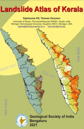
Landslide Atlas of Kerala
According to the authors, approximately 12 percent of land area in India is under the threat of landslides, and hence it is critical to develop workable management plans to minimize its effects.
“The goal of this atlas is to accomplish the first step towards managing landslide hazards in Kerala, ie, producing an easily accessible jargon-free atlas that marks out the spatial landslide hazard potential for each district of the state,” the authors said.
The atlas is divided into 15 chapters, designed mainly in the form of illustrations with description. Chapter 1 provides a holistic introduction to landslides, Chapter 2 deals with the landslides in Kerala in general whereas Chapters 3 to 15 looks into the 13 landslide-prone districts of Kerala. Alappuzha, the coastal district free of landslides is excluded.
Each chapter (3-15) highlights a district and consists of a district-wide landslide susceptibility map, major locations of landslides and its description, any one of the influencing factor that is dominant or any manifestations of that factor in the area, and mentions about major engineering projects, if any. A fact file showing main features of the district is also provided.
Oommen and Sajinkumar compiled all of the maps using a new tool called GIS-TISSA. TISSA stands for Tool for Infinite Slope Stability Analysis and was developed within a GIS environment. The program's algorithms calculate how different factors interact with one another and assess the landslide vulnerability of an area.
GIS-TISSA uses Python to interface with one of the most widely used geospatial tools in the world: ArcGIS. It will help the geospatial community evaluate landslide hazards caused by rainfall and earthquakes through a GIS tool they are already comfortable using. Oommen’s graduate student Jonathan Sanders and postdoctoral fellow Rudiger Escobar-Wolf also contributed to GIS-TISSA development.
The Landslide Atlas of Kerala sets a new standard for determining risk in a landslide-prone region and will help the residents and policymakers of the state make decisions to better mitigate life-threatening disasters.
Get it now and save 10%
BECOME A MEMBER

Bibliographic information
Thomas Oommen