
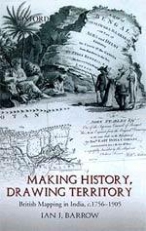
Making History, Drawing Territory: British Mapping in India, c. 1756-1905
Synopsis
This book explores the history of cartography in colonial India, combining a study of representation with an in-depth analysis of power and imperial control. It examines British possession and territorial legitimacy in India as represented by colonial maps, focusing on the articulation and manipulation of the past using cartographic perspectives and idioms.The cartographic efforts to make colonial rule seem legitimate are evident in maps that date from as early as the mid-eighteenth century to as late as the twentieth century. Surveyors and map-makers strategically embedded histories of British territorial possession into their visual narratives. These histories, whether associative, progressive, reverential, romantic, or nostalgic, were used to one end: to make British rule appear natural, appropriate, and reasonable. Throughout the colonial period, imperial authorities and independent British cartographers published maps that helped bolster a British sense of entitlement to overseas power. However, these maps of India were more than just means of legitimizing colonial rule; they also helped to fashion a sense of what it meant to be British, contributing to the strengthening of a British imperial national identity. As the author demonstrates, the maps--through their skilled interweaving of history, territory, and national identity--proved to be powerful instruments of propaganda in the hands of the modern colonial state.
Read more
34.47
31.023
$
38.30 $
Free delivery Wolrdwidе in 10-18 days
Ships in 1-2 days from New Delhi
Membership for 1 Year $35.00
Get it now and save 10%
Get it now and save 10%
BECOME A MEMBER


Bibliographic information